Vatnajokull National Park: the Park Around the Ice
The ice cap is the middle of a much larger park. If you are planning Vatnajokull national park tours, it helps to know which part of the park each tour uses, what the rules are, and why a glacier this size sits on top of volcanoes.
Fire and ice: what the park protects
Vatnajökull National Park covers more than 1,400,000 hectares, nearly 14% of Iceland. It is the largest national park in the country. At its centre is the ice cap itself, which the park measured at around 7,500 km² in 2023: Europe's largest ice cap by volume.
- Area of the park
- Over 1,400,000 ha, nearly 14% of Iceland
- Area of the ice cap
- Around 7,500 km² in 2023, about 7% of Iceland
- Volcanoes
- Ten central volcanoes, eight of them under the ice
- Ice lost
- more than 15% of the ice cap's volume in the last century
- World Heritage
- Inscribed on 5 July 2019, under natural criterion (viii)
UNESCO listed the park for what the park itself calls the dynamic nature of fire and ice. Eruptions under the glacier melt it from below and release sudden floods, the jökulhlaups. Those floods built the black outwash plains you drive across on Route 1.
From Skaftafell (1967) to UNESCO (2019)
The park you visit today grew out of a much smaller one. These are its dates, as the park records them.
- 15 September 1967. Skaftafell National Park is founded.
- 7 June 2008. Vatnajökull National Park is founded, and Skaftafell becomes part of it.
- 2017. Breiðamerkursandur, the plain around the glacier lagoon, joins the park.
- 5 July 2019. The park is inscribed on the World Heritage List.
- 5 July 2022. The third edition of the Management and Conservation Plan comes into force.
- 1 January 2025. The new Nature Conservation Agency of Iceland takes over running the park.
For you, the 2017 date matters most. It is why the lagoon and the beach across the road now sit inside the park, with the same parking fee as Skaftafell.
Öræfajökull and Hvannadalshnjúkur
The ice above Skaftafell hides a volcano. Öræfajökull erupted in 1362, the largest pumice eruption in Iceland's recorded history. It destroyed the farms below, and it erupted again in 1727. The district was then renamed Öræfi, which means wasteland.
Hvannadalshnjúkur, the highest peak in Iceland, stands on the rim of Öræfajökull. Its trail starts at Háalda by Sandfell. It is a serious glacier climb, not a day walk, so ask the rangers first.
You meet this volcano on almost every Skaftafell tour. Falljökull, where most glacier hikes go, flows down from its caldera. The Tröll ice climb goes onto Svínafellsjökull, its neighbour.
Breiðamerkursandur and the lagoons
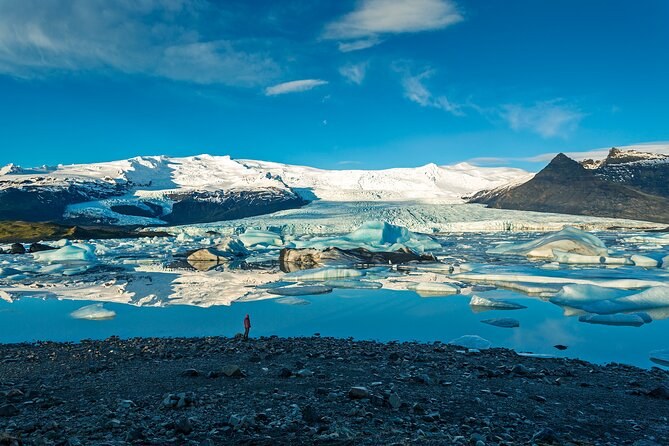
East of Skaftafell, Breiðamerkurjökull reaches down onto a wide sandur. In the Little Ice Age it came to within about 250 metres of the sea. As it retreated, lagoons began to form in the 1930s. The largest are Jökulsárlón, Breiðárlón and Fjallsárlón, and all three are still growing.
This is the ice-cave side of the park. The caves you can visit from the lagoon car park are in Breiðamerkurjökull, and the park's rangers here look after them. The rangers are on duty every day of the year, on 842-4355.
The Hornafjörður glacier tongues
Further east, four glacier tongues come down close to the farms of Hornafjörður: Skálafellsjökull, Heinabergsjökull, Fláajökull and Hoffellsjökull. The park calls it rare to find glaciers this close to settled land. From autumn to spring you often see large herds of reindeer here.
Skálafellsjökull is the one you can ride on. The snowmobile tour drives up the Skálafellsjökull road to the ice cap, then gives you about an hour on a machine. Heinabergsjökull shows how fast the ice moves the land. A bridge built over its river in 1947 and 1948 was left over a dry bed by the autumn of 1948, when the river shifted west.
Rules inside the park
Most rules are about birds, paths and safety. Drones are the one you are most likely to break by accident. You may fly in front of Skaftafellsjökull at set hours, but nowhere else in Skaftafell, and never at the lagoon while birds nest.
| Rule | What the park says | Where |
|---|---|---|
| Drones | Allowed in general, but banned in most of Skaftafell; in front of Skaftafellsjökull only at set hours | Skaftafell |
| Drones, nesting season | Banned from 15 April to 15 July; time-of-day limits the rest of the year | The lagoon and the beach |
| Tents | Only on marked campsites on Skaftafellsheiði, in Bæjarstaðarskógur and Morsárdalur; allowed above 400 m in Skaftafellsfjöll | Skaftafell |
| Driving | Only on roads shown on the park's own maps | The whole park |
| Dogs | On a leash | The whole park |
| Fires | No open fires | The whole park |
| Paths | Stay on marked or clearly defined routes; build no cairns | The whole park |
Commercial filming needs a permit from the park. If you are camping, only the marked campsites are allowed in the busy valleys. You may pitch a tent above 400 metres in the mountains or at the mouth of the Kjós.
Which tours go where
The glacier walks and ice caves here run under contracts with the park. Where your tour starts decides which glacier you stand on.
| Area of the park | What the ice is | Kinds of tour that go there |
|---|---|---|
| Skaftafell | Falljökull and Svínafellsjökull, outlet glaciers of Öræfajökull | Glacier hikes, the ice climb and hike-and-cave tours |
| Breiðamerkursandur | Breiðamerkurjökull, the glacier behind the lagoon | Ice caves by 4x4 from the lagoon car park, the kayak, the lagoon day |
| The Hornafjörður tongues | Skálafellsjökull, climbed by road to the ice cap | The snowmobile |
The lagoon day from Reykjavík stops at Jökulsárlón and the beach but never goes onto the ice. If you want to stand on it, choose a tour that starts at Skaftafell or at the lagoon car park.
Know which part of the park you want?
Hikes and the ice climb start at Skaftafell, caves and the kayak at the lagoon, and the snowmobile further east.
Asked about the park
How big is Vatnajökull?
Is Vatnajökull a UNESCO site?
Is Vatnajökull melting?
Who runs Vatnajokull National Park?
Where is Iceland's highest peak?
Can I fly a drone at Skaftafell or Jökulsárlón?
Can I camp at Skaftafell?
Where these facts come from
Every date, figure and rule here is the national park's own, read 23 September 2026. What each tour does on the ice comes from its own listing, saved 23 September 2026.
- The ice cap: size, volume and the volcanoes beneath (national park)
- World Heritage: fire and ice (national park)
- The national park: management and news (national park)
- Skaftafell: access, history and trails (national park)
- Breiðamerkursandur: how the lagoons formed (national park)
- Heinaberg and the eastern glacier tongues (national park)
- Travel advice: weather, roads, tents and the code of conduct (national park)
- Rules for recreational drones (national park)
Next: walk the park yourself with the trails and lagoons, read why the ice needs a guide, or compare every fare on Vatnajokull Tours.